7 ways the Military
Uses GPS:Navigation
For a soldier operating under cover of
darkness in enemy territory the biggest
challenge is navigation due to unfamiliar
territory and lack of easily identifiable
landmarks on ground. Soldiers have been
using night skies for ages to find out
direction but their location on ground
cannot be determined. The necessity of
knowing their own position by troops during
war was very clearly highlighted during the
Gulf War (1990) and the Kargil conflict
(1999). This can be judged from the fact
that initially about 1000 GPS receivers were
issued for use during the Gulf war but by
the end nearly 9000 handheld devices were in
use (Fig 2). Similarly, during the Kargil
conflict, Indian patrols operating in rugged
terrain along the line of control, initially
strayed into enemy held areas with
disastrous consequences but later on the
availability of handheld GPS receivers
proved to be invaluable to them. In fact,
these GPS receivers are fast replacing the
conventional compasses in a soldiers rug
sack. Special forces and crack teams also
use these to reach and destroy vital enemy
installations. Such teams can draw air and
artillery fire accurately by providing the
accurate positional data. Further, gun
positions can be occupied quickly using GPS,
as in modern warfare, artillery batteries
must move often to keep pace with assault
troops and to avoid being hit by counter
fire. Convoy movements can also be tracked
and planned effectively using GPS devices.
Tracking
In a military scenario, potential targets
need to be constantly tracked before they
are declared hostile and engaged by various
weapon systems. This tracking data is fed as
input to modern weapon systems such as
missiles and smart bombs etc. Just to site
an example, the US Army has developed a GPS
Truth Data Acquisition, Recording, and
Display System (TDARDS). It is a compact,
lightweight, low-cost, and easily
transportable or mobile GPS-based tracking
system that uses up-to-date GPS data, radio
data link, and computer technology to
provide highly accurate, real-time
time-space position information (TSPI) on up
to ten test objects, such as ground
vehicles, helicopters, and fixed-wing
aircraft. The system is highly modular,
built with commercial off-the-shelf
hardware, and easily modifiable to meet any
special needs of individual testing and
tracking applications (Gilkey et al., 1994).
Bomb and Missile guidance
Modern day weapon systems are designed to
use GPS data as input for targeting and
guidance. Cruise missiles commonly used by
US to accurately hit targets from large
standoff distances use multichannel GPS
receivers to accurately determine their
location constantly while in flight. The
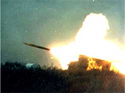
Multiple Launched Rocket System (MLRS)
vehicle uses GPS based inertial guidance to
position itself and aim the launch box at
the target in a very short time (Fig 3).
This reduces the chances of detection and
counter bombardment. The Exploitation of
DGPS for Guidance Enhancement (EDGE) program
of the US army has developed a 2000 lb glide
bomb, which uses a GPS seeker rather than a
Laser for guidance. This bomb could
accurately hit its target 11 miles from its
drop point guided by four DGPS base stations
about 1000 nautical miles away
(Anonymous(a), 2001).
Rescue
Rescue and emergency response is another
area where GPS can prove invaluable to the
military. Determining the location of a
casualty during operations, emergency
response teams can use the GPS to reduce
response time. For example, the US Air Force
is already taking advantage of GPS based
technology and is developing a Combat
Survivor Evader Locator (CSEL) system. The
new system integrates the GPS receiver with
a communications radio so that search and
rescue teams can locate downed aircrew
members faster and more accurately than
before (Anonymous(b), 2001).
Map Updation
To carry out planning at various military
headquarter levels, the defense forces need
accurate and updated maps at various scales
depending
upon the level of the commander for planning
operations, administrative planning and
training. The availability of GPS shall
augment the collection of precise data
necessary for quick and accurate map
updation. The GPS can also be used
effectively for the establishment of grid
control locations for the placement of
various weapons and other assets, location
of targets etc. For example, the modern
mapping techniques such as remote sensing
and GIS will now constantly use the DGPS
technology to register the images into
absolute geocoordinates (Kelly, 2001). This
would enable the military personnel to
utilize modern map products to accurately
determine the locations of target points for
use by the new generation of weapons.
Facility Management
In almost all countries of the world, the
military manages and operates large bases
which cover extensive areas. To manage these
facilities effectively, it is essential to
prepare an accurate base map. Here GPS/DGPS
can be of immense help, as existing maps are
not updated regularly. GPS co-opted with
Geographic Information System (GIS) can
effectively tackle this task. For example,
at Yokosuka US Naval Base in Japan, Arc View
GIS software was used to evaluate three
different components for the GPS
implementation. First, for modeling the
optimum location for a GPS base station,
secondly for selecting benchmark locations
to fix the base station location and thirdly
evaluating accuracy of survey by GPS
(Dunham, 1999).
Conclusions
With war clouds looming large over the west
Asian region, the world is likely to witness
the state of the art weaponry being used by
the US led forces. Most of these, either
directly or indirectly shall be using GPS to
accurately target and achieve the desired
results. This paper has demonstrated the
capabilities of GPS receivers for various
kinds of military activities both during war
and peace. Depending upon the nature of
activity (i.e., navigation or precise target
location), a particular kind of GPS may be
used. It may thus be summarized that the GPS
based weapon systems are here to stay and
will form the backbone for the future
development of better, more accurate and
lethal munitions.